
The Trinity River is one of the largest in Texas. It runs along the entire territory of the state. This river originates in extreme north Texas from three tributaries, namely the East Fork, the Elm Fork and the West Fork. It is 710 miles long. Read more about its history and role for the city on dallas-name.
The origin of the river’s name
It is believed that at first the river had the name Arkikosa, which it received from the Indians. In 1687, the French explorer Robert Cavelier de La Salle studied the area and named the river Riviere des Canoës. That name meant canoe river in French. However, it did not get popular. Three years later, the Spanish researcher Alonso de Leon came here and named the river La Santísima Trinidad, which translated as Holy Trinity. The researcher chose this name because he discovered the river two days before the feast of the Holy Trinity. It was a usual practice for Spanish Catholics to associate the names of places with religion.
The attempt to develop shipping
As in many other cities where rivers flow, the residents of Dallas tried to make the most of the potential of the reservoir and develop water transportation. During the 1830s, small boats were used to deliver cotton, sugar, leather, groceries and clothing via the river. However, their movement was often hindered by snags, sandbanks or a shallow bottom since the river is not deep. In the 1850s, a major survey of the Trinity was carried out. It found that seven steamboats were sailing in the lower part of the river and that the river was sufficiently navigable.
With the development of the railroad in Dallas in the early 1870s, the demand for water transportation began to decline. However, due to the high railroad rates, efforts were made to continue developing shipping on the Trinity River and turning Dallas into a port city.
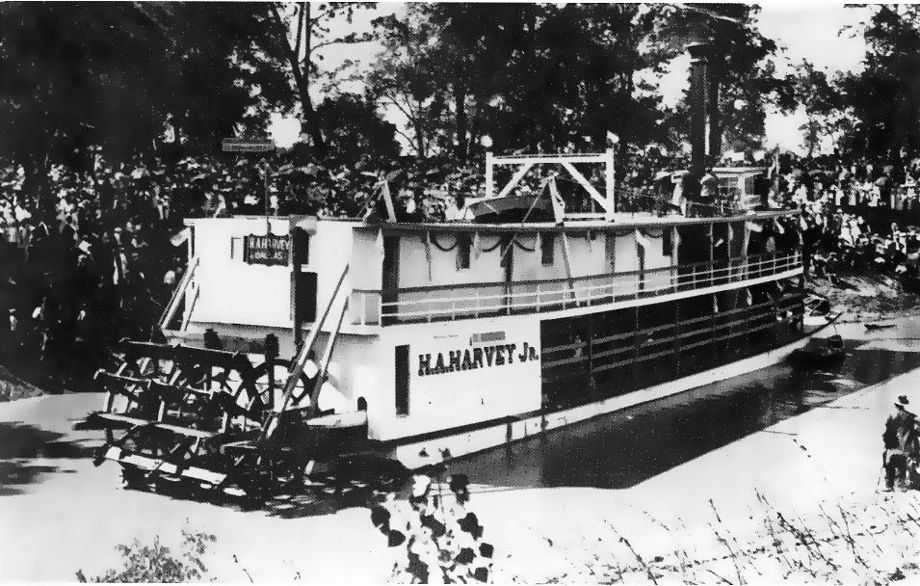
In 1892, the Snag Boat Dallas of Dallas was launched on the river to clear garbage. This allowed the passage of a passenger steamer named HA Harvey Jr. It was a high-profile event that was covered on the front pages of newspapers. Dallas convinced Congress to survey the Trinity River and determine where locks and levees would help make it navigable.
In the early 1990s, the first lock and dam was completed 13 miles from Dallas. However, Congress never adopted the whole project.
Is the Trinity River a threat to Dallas?
Despite the fact that rivers in cities bring many benefits, they can also be dangerous. Thus, the Trinity River was flooded several times in 1844, 1866, 1871 and 1890. The greatest damage was caused by the flood of 1908. The width of the river increased to 2.4 kilometers and the depth reached 16 meters. Then, 5 people died and about 4 thousand residents of the city lost their homes. Several hundred heads of livestock also died and the smell of their corpses lingered in the city for a long time after the water receded.
Dallas was left without power, communication and rail service for three days. It was possible to move around the city only by boat. West Dallas was the hardest hit. In total, losses of $2.5 million were caused.
To prevent another such tragedy, the city hired a German city planner, George Kessler. He developed the Kessler Plan, which called for the construction of a system of levees to channel the river and the realignment of streets and railroads. Most of the ideas were implemented by the 1930s.
The flood also destroyed a wooden bridge connecting Dallas and Oak Cliff, which was then a separate area. Dallas Morning News publisher George B. Dealey suggested building a concrete bridge. The new Oak Cliff Viaduct (nowadays the Houston Street Viaduct) over the Trinity River was completed in 1912. At that time, the viaduct was the longest concrete structure in the world.